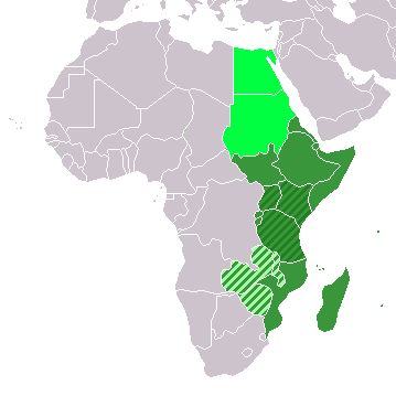
सञ्चिका:LocationEasternAfrica.png
LocationEasternAfrica.png (३५९ × ३५९ चित्राणवः (pixels), सञ्चिकायाः आकारः: ८ KB, MIME-प्रकारः: image/png)
सञ्चिकायाः इतिहासः
सञ्चिका तत्समये कीदृशी आसीदिति द्रष्टुं दिनाङ्कः/समयः नुद्यताम् ।
| दिनाङ्कः/समयः | लघ्वाकृतिः | आयामाः | सदस्यः | टिप्पणी | |
|---|---|---|---|---|---|
| वर्तमानः | १३:१६, ११ नवेम्बर् २०२२ |  | ३५९ × ३५९ (८ KB) | ColorfulSmoke | . |
| ११:५४, ११ नवेम्बर् २०२२ |  | ३६० × ३५९ (८ KB) | ColorfulSmoke | ||
| १७:०१, १७ मार्च् २०१८ |  | ३६० × ३९२ (११ KB) | Maphobbyist | Upload | |
| ००:३०, २० डिसेम्बर् २०१२ |  | ३६० × ३९२ (८ KB) | Spacepotato | Recolor to reflect placement of South Sudan in Eastern Africa according to the UN classification scheme, http://unstats.un.org/unsd/methods/m49/m49regin.htm . | |
| १७:०१, ९ जुलै २०११ |  | ३६० × ३९२ (१४ KB) | Maphobbyist | South Sudan has become independent on July 9, 2011. Sudan and South Sudan are shown with the new international border between them. | |
| ०८:१५, ११ डिसेम्बर् २००७ |  | ३६० × ३९२ (१४ KB) | Hoshie | added Cabinda (Angola) and Montenegro. | |
| १५:५६, २ एप्रिल् २००६ |  | ३६० × ३९२ (९ KB) | E Pluribus Anthony~commonswiki | Reverted to earlier revision | |
| ०५:४७, १ एप्रिल् २००६ |  | ३६० × ३९२ (१४ KB) | Aris Katsaris | No need to include regional organizations -- it makes the map much harder to read for no relevant purpose. The map should be clear in its purpose. | |
| १२:३७, ५ फेब्रवरी २००६ |  | ३६० × ३९२ (९ KB) | E Pluribus Anthony~commonswiki | Map: Eastern Africa (location) |
सञ्चिकायाः उपयोगः
अधोलिखितानि 2 पृष्ठानि इदं संचिकां प्रति संबंधनं कुर्वन्ति।
वैश्विकसञ्चिकायाः उपयोगः
एतां सञ्चिकाम् अधोनिर्दिष्टाः वीक्यः उपयुञ्जते:
- ace.wikipedia.org इत्यस्मिन् उपयोगः
- af.wikipedia.org इत्यस्मिन् उपयोगः
- als.wikipedia.org इत्यस्मिन् उपयोगः
- am.wikipedia.org इत्यस्मिन् उपयोगः
- ar.wikipedia.org इत्यस्मिन् उपयोगः
- ليبيا
- جيبوتي
- موريتانيا
- تونس
- السودان
- الصحراء الغربية
- أنغولا
- أوغندا
- إسبانيا
- تشاد
- النيجر
- مالي
- السنغال
- غامبيا
- غينيا بيساو
- غينيا
- سيراليون
- ليبيريا
- غانا
- توغو
- بنين
- بوركينا فاسو
- الصومال
- كينيا
- تنزانيا
- الغابون
- زامبيا
- موزمبيق
- زيمبابوي
- البرتغال
- الكاميرون
- جمهورية الكونغو الديمقراطية
- بوتسوانا
- جنوب إفريقيا
- جمهورية إفريقيا الوسطى
- جمهورية الكونغو
- سيشل
- ناميبيا
- مدغشقر
- ليسوتو
- موريشيوس
- نهر النيل
अस्याः सञ्चिकायाः वैश्विकोपयोगस्य अधिकविवरणम् दृश्यताम् ।

