सञ्चिका:ROC Administrative and Claims.svg

पूर्वावलोकन PNG का आकार SVG फ़ाइल: ७५४ × ६०० पिक्सेल् अन्याः प्रस्तावाः: ३०२ × २४० पिक्सेल् | ६०३ × ४८० पिक्सेल् | ९६५ × ७६८ पिक्सेल् | १,२८० × १,०१९ पिक्सेल् | २,५६० × २,०३७ पिक्सेल् ।
मूलसञ्चिका (SVG सञ्चिका, साधारणं ७५४ × ६०० चित्राणवः (pixels), सञ्चिकायाः आकारः : ६७६ KB)
सारांशः
| वर्णनम् |
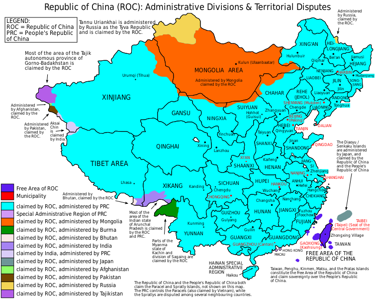
English: Map of the Republic of China (1953-2005), showing administrative divisions and territorial disputes. |
| दिनाङ्क | (UTC) |
| स्रोतः | I (ZanderSchubert (talk)) created this work entirely by myself. |
| लेखकः | User:ZanderSchubert |
| अन्यानि संस्करणानि |
Based on a previous version of File:ROC_Administrative_and_Claims.jpg See also the other versions of this file:
Derivative works of this file: |


|
इस SVG फ़ाइल में एम्बेड किया हुआ टेक्स्ट है जिसे आप अपनी भाषा में किसी भी सक्षम SVG एडिटर, टेक्स्ट एडिटर, या फिर SVG Translate उपकरण की मदद से अनुवादित कर सकते हैं। अधिक जानकारी के लिए देखें: SVG फ़ाइलों को अनुवादित करने के बारे में। |
अनुमतिदानम्
अहम्, अस्य कार्यस्य कृतिस्वाम्यवान्, अत्र अस्याः अनुमतिद्वारा प्रकाशयन् अस्मि :

|
अस्य प्रलेखस्य प्रतिकृतीकरणं, पुनर्वितरणं, परिवर्तनं वा / च कर्तुम् अधोनिर्दिष्टनियमानुसारम् अनुमतिः दत्ता GNU Free Documentation License, Version 1.2 or any later version published by the Free Software Foundation; with no Invariant Sections, no Front-Cover Texts, and no Back-Cover Texts. A copy of the license is included in the section entitled GNU Free Documentation License |
This file is licensed under the Creative Commons Attribution-Share Alike 4.0 International, 3.0 Unported, 2.5 Generic, 2.0 Generic and 1.0 Generic license.
- त्वं स्वतन्त्रः/स्वतन्त्रा :
- वितरितकरणार्थम् – प्रतिलिपिकरणार्थं, वितरितकरणार्थं, सञ्चारितकरणार्थं च
- सुशोभयितुम् (to remix) – कार्यम् अनुकूलं करणार्थम्
- निम्नलिखितावस्थानाम् अन्तर्गततया :
- समारोपः (attribution) – भवता/भवत्या रचनायाः श्रेयः उपयोगसंस्थितकत्रा अथवा लेखकेन दर्शितमाध्यमेन दातव्यः भविष्यति । (परन्तु सः भवते/भवत्यै अथवा भवता/भवत्या रचनायाः प्रयोगस्य समर्थनं करोति इति तस्य विचारः न भवेत्)।
- समानतया वितर्यताम् – यदि भवान्/भवती एतस्मिन् कार्ये किमपि परिवर्तनं, अस्य आधारेण नवीनरचनां वा करोति, तर्हि नवरचितरचनायाः वितरणम् एतस्याः उत एतादृश्याः उपयोगसंस्थित्याः अन्तर्गततया कर्तुं शक्नोति ।
भवतः इच्छानुसारम् अनुमतेः चयनं कर्तुम् अर्हति ।
सञ्चिकायाः इतिहासः
सञ्चिका तत्समये कीदृशी आसीदिति द्रष्टुं दिनाङ्कः/समयः नुद्यताम् ।
| दिनाङ्कः/समयः | लघ्वाकृतिः | आयामाः | सदस्यः | टिप्पणी | |
|---|---|---|---|---|---|
| वर्तमानः | १०:३८, ४ जून् २०१५ | | ७५४ × ६०० (६७६ KB) | Storkk | fix typo ("Most if ... Arunchal Pradesh" -> "Most of ...") |
| २०:०९, २५ डिसेम्बर् २०१४ |  | ७५४ × ६०० (६५८ KB) | Koavf | Burma | |
| १३:२४, ४ मे २०१२ |  | ७५४ × ६०० (६७७ KB) | Michaeldsuarez | Removing typo: "[…] claimed by the Republic of China an the People's Republic of China" to "[…] claimed by the Republic of China and the People's Republic of China." | |
| ०८:०२, ५ आगस्ट् २०११ |  | ७५४ × ६०० (६७७ KB) | ZanderSchubert | Changing place names to Pinyin and correcting some previous errors. | |
| ०१:००, ५ मे २०११ |  | ७५४ × ६०० (६७५ KB) | ZanderSchubert | Changing "Republic of Mongolia" to "Mongolia" | |
| ०४:२२, १२ फेब्रवरी २०११ |  | ७५४ × ६०० (६७५ KB) | ZanderSchubert | {{Information |Description ={{en|1=Map of the Republic of China, showing administrative divisions and territorial disputes.}} |Source =I (ZanderSchubert (talk)) created this work entirely by |
सञ्चिकायाः उपयोगः
अधोलिखितं पृष्ठं इदं संचिकां प्रति संबंधनं करोति।
वैश्विकसञ्चिकायाः उपयोगः
एतां सञ्चिकाम् अधोनिर्दिष्टाः वीक्यः उपयुञ्जते:
- af.wikipedia.org इत्यस्मिन् उपयोगः
- ar.wikipedia.org इत्यस्मिन् उपयोगः
- ast.wikipedia.org इत्यस्मिन् उपयोगः
- azb.wikipedia.org इत्यस्मिन् उपयोगः
- ban.wikipedia.org इत्यस्मिन् उपयोगः
- be-tarask.wikipedia.org इत्यस्मिन् उपयोगः
- be.wikipedia.org इत्यस्मिन् उपयोगः
- bn.wikipedia.org इत्यस्मिन् उपयोगः
- ca.wikipedia.org इत्यस्मिन् उपयोगः
- cs.wikipedia.org इत्यस्मिन् उपयोगः
- de.wikipedia.org इत्यस्मिन् उपयोगः
- el.wikipedia.org इत्यस्मिन् उपयोगः
- en.wikipedia.org इत्यस्मिन् उपयोगः
- Taiwan
- User:Jaques O. Carvalho
- Exclusive mandate
- User:Andyso/Userboxes
- User:Andyso/template:userboxes
- Template:User ROC Support
- Talk:2011 Cricket World Cup/Archive 2
- Talk:List of sovereign states/Archive 10
- Talk:Chinese civilization/Archive 26
- Talk:Sino-Burmese War/Move
- Wikipedia talk:WikiProject China/Archive 21
- Administrative divisions of the Republic of China (1912–1949)
- User:Skirtland/sandbox
- Wikipedia:Userboxes/Politics by country/05
- Talk:Taiwan/Archive 27
- User:Falcaorib
- Talk:COVID-19 pandemic/Archive 2
- User:DefinitelyNotNapoleon
- User:Pasingr
- User:TomcatEnthusiast1986
- User:Ezoiar/Userboxes
- Draft:Republic of China (Taiwan)
- eu.wikipedia.org इत्यस्मिन् उपयोगः
- fa.wikipedia.org इत्यस्मिन् उपयोगः
- fi.wikipedia.org इत्यस्मिन् उपयोगः
- fr.wikipedia.org इत्यस्मिन् उपयोगः
अस्याः सञ्चिकायाः वैश्विकोपयोगस्य अधिकविवरणम् दृश्यताम् ।