सञ्चिका:Vijayanagara-empire-map.svg

पूर्वावलोकन PNG का आकार SVG फ़ाइल: ५१४ × ६०० पिक्सेल् अन्याः प्रस्तावाः: २०६ × २४० पिक्सेल् | ४११ × ४८० पिक्सेल् | ६५८ × ७६८ पिक्सेल् | ८७७ × १,०२४ पिक्सेल् | १,७५५ × २,०४८ पिक्सेल् | १,५८५ × १,८५० पिक्सेल् ।
मूलसञ्चिका (SVG सञ्चिका, साधारणं १,५८५ × १,८५० चित्राणवः (pixels), सञ्चिकायाः आकारः : ३७२ KB)
rambabu
सारांशः
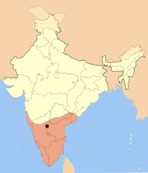
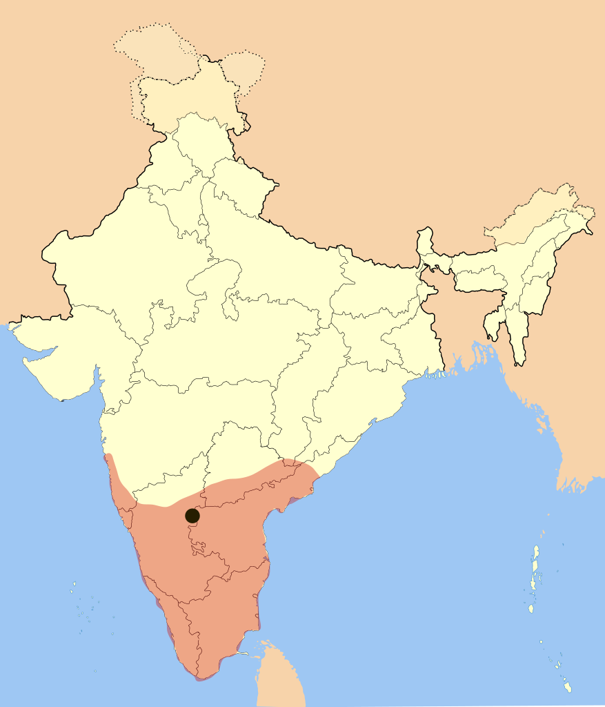
I used Image:India-locator-map-blank.svg as base and edited myself using Inkscape and created it by looking at the following sources.
- Dr. Suryanath U. Kamath, A Concise history of Karnataka from pre-historic times to the present, Jupiter books, MCC, 2001 (Reprinted 2002) (page no - 329)
- Durga Prasad, History Andhras upto 1565 A. D., 1988, P.G. Publishers, Don Bosco School Press, Guntur, p268-270(page no - 234)
- and http://www.britannica.com/eb/art-1959
Empire was under its peak when Goa was captured and won many portions of Andhra Pradesh from Gajapati's of Orissa.
Color and opacity are changed on May 27, 2007.
अनुमतिदानम्
अहम्, अस्य कार्यस्य कृतिस्वाम्यवान्, अत्र अस्याः अनुमतिद्वारा प्रकाशयन् अस्मि :

|
अस्य प्रलेखस्य प्रतिकृतीकरणं, पुनर्वितरणं, परिवर्तनं वा / च कर्तुम् अधोनिर्दिष्टनियमानुसारम् अनुमतिः दत्ता GNU Free Documentation License, Version 1.2 or any later version published by the Free Software Foundation; with no Invariant Sections, no Front-Cover Texts, and no Back-Cover Texts. A copy of the license is included in the section entitled GNU Free Documentation License |
| एषा सञ्चिका क्रिएटिव कॉमन्स-Attribution-Share Alike 3.0 Unported अनुमतिपत्रान्तर्गततया अस्ति । | ||
| ||
| इयम् अनुमतिशृङ्खला GFDL भागत्वेन अस्यां सञ्चिकायां योजितम् अनुमतेः अद्यतनीकरणम् । |
इस फ़ाइल को क्रिएटिव कॉमन्स श्रेय-समानसांझा 2.5 साधारण, 2.0 साधारण और 1.0 साधारण लाइसेंस के अंतर्गत लाइसेंस किया गया है।
- त्वं स्वतन्त्रः/स्वतन्त्रा :
- वितरितकरणार्थम् – प्रतिलिपिकरणार्थं, वितरितकरणार्थं, सञ्चारितकरणार्थं च
- सुशोभयितुम् (to remix) – कार्यम् अनुकूलं करणार्थम्
- निम्नलिखितावस्थानाम् अन्तर्गततया :
- समारोपः (attribution) – भवता/भवत्या रचनायाः श्रेयः उपयोगसंस्थितकत्रा अथवा लेखकेन दर्शितमाध्यमेन दातव्यः भविष्यति । (परन्तु सः भवते/भवत्यै अथवा भवता/भवत्या रचनायाः प्रयोगस्य समर्थनं करोति इति तस्य विचारः न भवेत्)।
- समानतया वितर्यताम् – यदि भवान्/भवती एतस्मिन् कार्ये किमपि परिवर्तनं, अस्य आधारेण नवीनरचनां वा करोति, तर्हि नवरचितरचनायाः वितरणम् एतस्याः उत एतादृश्याः उपयोगसंस्थित्याः अन्तर्गततया कर्तुं शक्नोति ।
भवतः इच्छानुसारम् अनुमतेः चयनं कर्तुम् अर्हति ।
सञ्चिकायाः इतिहासः
सञ्चिका तत्समये कीदृशी आसीदिति द्रष्टुं दिनाङ्कः/समयः नुद्यताम् ।
| दिनाङ्कः/समयः | लघ्वाकृतिः | आयामाः | सदस्यः | टिप्पणी | |
|---|---|---|---|---|---|
| वर्तमानः | २०:०९, ३ मार्च् २०१७ | | १,५८५ × १,८५० (३७२ KB) | BurritoBazooka | rederive from new modern boundaries map. Some state borders have changed (Telangana). |
| ००:०५, २८ मे २००७ |  | १,६५१ × १,७५३ (४३२ KB) | Mlpkr | I used Image:India-locator-map-blank.svg as base and edited myself using inkspace and created it by looking at the following sources. * Dr. Suryanath U. Kamath, A Concise history of Karnataka from pre-historic times to the present, Jupiter books, MC | |
| १६:४९, २४ जनवरी २००७ |  | १,६५१ × १,७५३ (४३२ KB) | Mlpkr | All of the old copyrights with only difference, adding a dot for the capitol. | |
| २०:३४, १७ जनवरी २००७ |  | १,६५१ × १,७५३ (४२८ KB) | Mlpkr | == Summary == I used Image:India-locator-map-blank.svg as base and edited myself using inkspace and created it by looking at the following sources. * Dr. Suryanath U. Kamath, A Concise history of Karnataka from pre-historic times to the present, Jup |
सञ्चिकायाः उपयोगः
अधोलिखितानि 2 पृष्ठानि इदं संचिकां प्रति संबंधनं कुर्वन्ति।
वैश्विकसञ्चिकायाः उपयोगः
एतां सञ्चिकाम् अधोनिर्दिष्टाः वीक्यः उपयुञ्जते:
- ast.wikipedia.org इत्यस्मिन् उपयोगः
- azb.wikipedia.org इत्यस्मिन् उपयोगः
- ba.wikipedia.org इत्यस्मिन् उपयोगः
- be.wikipedia.org इत्यस्मिन् उपयोगः
- bg.wikipedia.org इत्यस्मिन् उपयोगः
- bn.wikipedia.org इत्यस्मिन् उपयोगः
- br.wikipedia.org इत्यस्मिन् उपयोगः
- ca.wikipedia.org इत्यस्मिन् उपयोगः
- cs.wikipedia.org इत्यस्मिन् उपयोगः
- da.wikipedia.org इत्यस्मिन् उपयोगः
- de.wikipedia.org इत्यस्मिन् उपयोगः
- en.wikipedia.org इत्यस्मिन् उपयोगः
- en.wikivoyage.org इत्यस्मिन् उपयोगः
- eo.wikipedia.org इत्यस्मिन् उपयोगः
- eu.wikipedia.org इत्यस्मिन् उपयोगः
- fa.wikipedia.org इत्यस्मिन् उपयोगः
- fi.wikipedia.org इत्यस्मिन् उपयोगः
- gl.wikipedia.org इत्यस्मिन् उपयोगः
- gu.wikipedia.org इत्यस्मिन् उपयोगः
- he.wikipedia.org इत्यस्मिन् उपयोगः
- hi.wikipedia.org इत्यस्मिन् उपयोगः
- hr.wikipedia.org इत्यस्मिन् उपयोगः
- hu.wikipedia.org इत्यस्मिन् उपयोगः
- hy.wikipedia.org इत्यस्मिन् उपयोगः
- id.wikipedia.org इत्यस्मिन् उपयोगः
- it.wikipedia.org इत्यस्मिन् उपयोगः
- ja.wikipedia.org इत्यस्मिन् उपयोगः
- ka.wikipedia.org इत्यस्मिन् उपयोगः
- kn.wikipedia.org इत्यस्मिन् उपयोगः
- lt.wikipedia.org इत्यस्मिन् उपयोगः
- ml.wikipedia.org इत्यस्मिन् उपयोगः
- mr.wikipedia.org इत्यस्मिन् उपयोगः
- ms.wikipedia.org इत्यस्मिन् उपयोगः
- ne.wikipedia.org इत्यस्मिन् उपयोगः
अस्याः सञ्चिकायाः वैश्विकोपयोगस्य अधिकविवरणम् दृश्यताम् ।