सञ्चिका:Map-of-southeast-asia 1300 CE.png
अस्य पूर्वावलोकनस्य आकारः : ४२६ × ५९९ पिक्सेल् अन्याः प्रस्तावाः: १७१ × २४० पिक्सेल् | ३४१ × ४८० पिक्सेल् ।
मूलसञ्चिका (८०० × १,१२५ चित्राणवः (pixels), सञ्चिकायाः आकारः: २५१ KB, MIME-प्रकारः: image/png)

|
This historical map image could be re-created using vector graphics as an SVG file. This has several advantages; see Commons:Media for cleanup for more information. If an SVG form of this image is available, please upload it and afterwards replace this template with
{{vector version available|new image name}}.
It is recommended to name the SVG file “Map-of-southeast-asia 1300 CE.svg”—then the template Vector version available (or Vva) does not need the new image name parameter. |
सारांशः
| वर्णनम् |
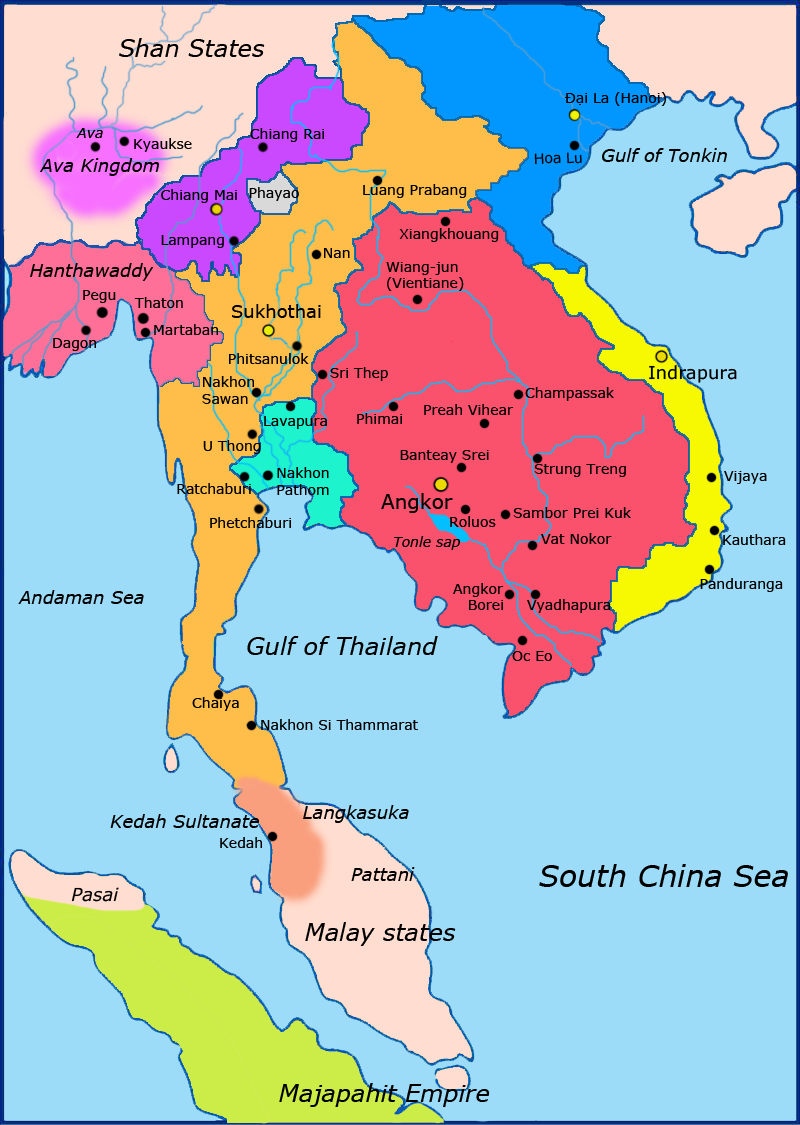
English: Map of Southeast Asia circa 1300 CE, showing Khmer Empire in red, Lavo kingdom/Dvaravati in light blue, Sukhothai empire in orange, Champa in yellow, Dai Viet in blue, Kingdom of Lanna in purple and surrounding states. |
| दिनाङ्क | |
| स्रोतः |
http://ecaimaps.berkeley.edu/animations/2003_03_khmer_animation.swf http://www.britannica.com/EBchecked/media/3395/Khmer-empire-1200 Atlas of world history, Patrick Karl O'brien. Societies, Networks, and Transitions: A Global History, Volume B. Craig A.Lockard http://upload.wikimedia.org/wikipedia/commons/thumb/4/45/Srivijaya_Empire.svg/2000px-Srivijaya_Empire.svg.png File:DvaravatiMapThailand.png http://upload.wikimedia.org/wikipedia/commons/e/eb/Thailand_2002_CIA_map.jpg |
| लेखकः | Javierfv1212 |
| अन्यानि संस्करणानि |

अनुमतिदानम्
अहम्, अस्य कार्यस्य कृतिस्वाम्यवान्, अत्र अस्याः अनुमतिद्वारा प्रकाशयन् अस्मि :
| इस फ़ाइल को क्रिएटिव कॉमन्स CC0 1.0 वैश्विक सार्वजनिक डोमेन समर्पण के अंतर्गत उपलब्ध कराया गया है। | |
| कार्य को इस आलेख से संबद्ध करने वाले व्यक्ति ने पूरे विश्व में कॉपीराइट कानूनों के अंतर्गत कार्य पर कानून की अनुमोदित सीमा तक सभी संबंधित अधिकारों समेत अपने सभी अधिकार त्यागकर इसे सार्वजनिक डोमेन को समर्पित किया है। आप बिना अनुमति के कार्य की प्रतियाँ बना सकते हैं, इसे बदल और पुनः वितरित कर सकते हैं, और प्रदर्शित कर सकते हैं, वाणिज्यिक उद्देश्यों से भी।
|
सञ्चिकायाः इतिहासः
सञ्चिका तत्समये कीदृशी आसीदिति द्रष्टुं दिनाङ्कः/समयः नुद्यताम् ।
| दिनाङ्कः/समयः | लघ्वाकृतिः | आयामाः | सदस्यः | टिप्पणी | |
|---|---|---|---|---|---|
| वर्तमानः | ०२:२३, २८ मार्च् २०११ | | ८०० × १,१२५ (२५१ KB) | Javierfv1212 | {{Information |Description ={{en|1=Map of Southeast Asia circa 1300 CE, showing Khmer Empire in red, Lavo kingdom/Dvaravati in light blue, Sukhothai empire in orange, Champa in yellow, Kingdom of Lanna in purple and surrounding states. sources http: |
सञ्चिकायाः उपयोगः
अधोलिखितं पृष्ठं इदं संचिकां प्रति संबंधनं करोति।
वैश्विकसञ्चिकायाः उपयोगः
एतां सञ्चिकाम् अधोनिर्दिष्टाः वीक्यः उपयुञ्जते:
- ar.wikipedia.org इत्यस्मिन् उपयोगः
- ast.wikipedia.org इत्यस्मिन् उपयोगः
- es.wikipedia.org इत्यस्मिन् उपयोगः
- fi.wikipedia.org इत्यस्मिन् उपयोगः
- fr.wikipedia.org इत्यस्मिन् उपयोगः
- id.wikipedia.org इत्यस्मिन् उपयोगः
- is.wikipedia.org इत्यस्मिन् उपयोगः
- it.wikipedia.org इत्यस्मिन् उपयोगः
- ja.wikipedia.org इत्यस्मिन् उपयोगः
- ka.wikipedia.org इत्यस्मिन् उपयोगः
- km.wikipedia.org इत्यस्मिन् उपयोगः
- ko.wikipedia.org इत्यस्मिन् उपयोगः
- lo.wikipedia.org इत्यस्मिन् उपयोगः
- ms.wikipedia.org इत्यस्मिन् उपयोगः
- my.wikipedia.org इत्यस्मिन् उपयोगः
- nl.wikipedia.org इत्यस्मिन् उपयोगः
- no.wikipedia.org इत्यस्मिन् उपयोगः
- pt.wikipedia.org इत्यस्मिन् उपयोगः
- ta.wikipedia.org इत्यस्मिन् उपयोगः
- th.wikipedia.org इत्यस्मिन् उपयोगः
- tr.wikipedia.org इत्यस्मिन् उपयोगः
- uk.wikipedia.org इत्यस्मिन् उपयोगः
- www.wikidata.org इत्यस्मिन् उपयोगः