सञ्चिका:Punjab in India.png
Punjab_in_India.png (३५० × ४२६ चित्राणवः (pixels), सञ्चिकायाः आकारः: ७६ KB, MIME-प्रकारः: image/png)
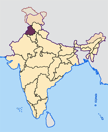
Map made by me, Nichalp
Note: The Indian state of w:Jammu and Kashmir is claimed by w:India, w:Pakistan and the w:People's Republic of China. This map depicts the boundaries of the state as it was in 1947. Areas administered by India is coloured as per the rest of the states, and the area administered by Pakistan and China are coloured in a neutral colour. See the map of Jammu and Kashmir.
The Indian state of w:Arunachal Pradesh is claimed by China as a part of w:South Tibet. The claimed region is depicted in a pale shade of pink. See the map of Arunachal Pradesh.
The Indian territorial waters extend to a distance of twelve nautical miles.

|
अस्य प्रलेखस्य प्रतिकृतीकरणं, पुनर्वितरणं, परिवर्तनं वा / च कर्तुम् अधोनिर्दिष्टनियमानुसारम् अनुमतिः दत्ता GNU Free Documentation License, Version 1.2 or any later version published by the Free Software Foundation; with no Invariant Sections, no Front-Cover Texts, and no Back-Cover Texts. A copy of the license is included in the section entitled GNU Free Documentation License |
| एषा सञ्चिका क्रिएटिव कॉमन्स-Attribution-Share Alike 3.0 Unported अनुमतिपत्रान्तर्गततया अस्ति । | ||
| ||
| इयम् अनुमतिशृङ्खला GFDL भागत्वेन अस्यां सञ्चिकायां योजितम् अनुमतेः अद्यतनीकरणम् । |
सञ्चिकायाः इतिहासः
सञ्चिका तत्समये कीदृशी आसीदिति द्रष्टुं दिनाङ्कः/समयः नुद्यताम् ।
| दिनाङ्कः/समयः | लघ्वाकृतिः | आयामाः | सदस्यः | टिप्पणी | |
|---|---|---|---|---|---|
| वर्तमानः | ०७:३३, २३ एप्रिल् २००५ | | ३५० × ४२६ (७६ KB) | Nichalp | NPOV map |
| ०७:२२, २३ एप्रिल् २००५ |  | २०० × २३१ (२२ KB) | Kerpal | Reverted to earlier revision | |
| ०६:२७, २३ एप्रिल् २००५ |  | ५०० × ६०८ (१२१ KB) | Nichalp | Reverted to earlier revision | |
| ०५:००, २३ एप्रिल् २००५ |  | २०० × २३१ (२२ KB) | Kerpal | Reverted to earlier revision | |
| ०४:५४, २३ एप्रिल् २००५ |  | ५०० × ६०८ (१२१ KB) | Nichalp | Reverted to earlier revision | |
| २१:०६, २२ एप्रिल् २००५ |  | २०० × २३१ (२२ KB) | Kerpal | Reverted to earlier revision | |
| १३:३८, २२ एप्रिल् २००५ |  | ५०० × ६०८ (१२१ KB) | Nichalp | Reverted to earlier revision | |
| ०९:४३, २२ एप्रिल् २००५ |  | २०० × २३१ (२२ KB) | Kerpal | originally by en:User:Morwen | |
| १८:०६, २१ एप्रिल् २००५ |  | ५०० × ६०८ (१२१ KB) | Nichalp | ---- Map made by me, ~~~ ---- Note: The Indian state of w:Jammu and Kashmir is claimed by w:India, w:Pakistan and the w:People's Republic of China. This map depicts the boundaries of the state as it was in 1947. Areas administered by Indi |
सञ्चिकायाः उपयोगः
अधोलिखितं पृष्ठं इदं संचिकां प्रति संबंधनं करोति।
वैश्विकसञ्चिकायाः उपयोगः
एतां सञ्चिकाम् अधोनिर्दिष्टाः वीक्यः उपयुञ्जते:
- awa.wikipedia.org इत्यस्मिन् उपयोगः
- bh.wikipedia.org इत्यस्मिन् उपयोगः
- अमृतसर जिला
- बरनाला जिला
- भटिंडा जिला
- फिरोजपुर जिला
- फरीदकोट जिला
- फतेहगढ़ साहिब जिला
- फजिल्का जिला
- गुरदासपुर जिला
- होशियारपुर जिला
- जालंधर जिला
- कपूरथला जिला
- लुधियाना जिला
- मानसा जिला
- मोगा जिला
- श्री मुक्तसर साहिब जिला
- पठानकोट जिला
- पटियाला जिला
- रूपनगर जिला
- संगरूर जिला
- शहीद भगत सिंह नगर जिला
- तरनतारन जिला
- टेम्पलेट:पंजाब
- bn.wikipedia.org इत्यस्मिन् उपयोगः
- bxr.wikipedia.org इत्यस्मिन् उपयोगः
- en.wikipedia.org इत्यस्मिन् उपयोगः
अस्याः सञ्चिकायाः वैश्विकोपयोगस्य अधिकविवरणम् दृश्यताम् ।