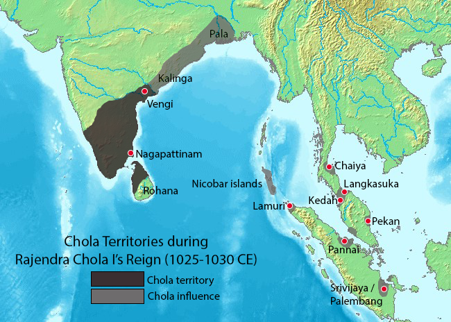
Rajendra_territories_cl.png(६५० × ४६४ चित्राणवः (pixels), सञ्चिकायाः आकारः: ५०४ KB, MIME-प्रकारः: image/png)

Wikimedia Commons इत्यतः उद्धृता एषा सञ्चिका अन्येषु प्रकल्पेषु उपयोगार्हा । अस्याः सञ्चिकायाः सञ्चिकाविवरणपृष्ठम् इत्यत्र उपलभ्यमानं विवरणम् अधोलिखितं वर्तते ।

सारांशः

वर्णनम्

Map showing the extent of the Chola empire during Rajendra Chola I.

Source of map: http://www2.demis.nl/mapserver/mapper.asp (mention : "Disclaimer: With this statement DEMIS BV grants you permission to freely copy the PNG images returned by our server and use them for your own purposes, including web pages. We would appreciate a reference to our server but such a reference is not required, nor do we take responsibility for the accuracy or quality of the maps". at http://www2.demis.nl/mapserver/DataSrc.htm)

Modified by myself using Adobe Photoshop.

Note: This file was imported to Commons by Nicke L on 25 June 2006, then updated based on https://commons.wikimedia.org/wiki/File:Rajendra_map_new.svg and https://en.wikipedia.org/wiki/Talk:Chola_dynasty#Maps by Verosaurus on 27 December 2022. Pegu isn't included in the influence area since the original map did not include that city.
स्रोतः Source of map: http://www2.demis.nl/mapserver/mapper.asp
लेखकः User Venu62 on en.wikipedia
अनुमतिः
(अस्याः सञ्चिकायाः पुनरुपयोगः)
Venu62 from en.wikipedia.org, अस्य कार्यस्य कृतिस्वाम्यवान्, अत्र अस्याः अनुमतिद्वारा प्रकाशयन् अस्मि :
GNU head अस्य प्रलेखस्य प्रतिकृतीकरणं, पुनर्वितरणं, परिवर्तनं वा / च कर्तुम् अधोनिर्दिष्टनियमानुसारम् अनुमतिः दत्ता GNU Free Documentation License, Version 1.2 or any later version published by the Free Software Foundation; with no Invariant Sections, no Front-Cover Texts, and no Back-Cover Texts. A copy of the license is included in the section entitled GNU Free Documentation License
w:hi:क्रिएटिव कॉमन्स
समारोपः (attribution) समानतया वितर्यताम्
एषा सञ्चिका क्रिएटिव कॉमन्स-Attribution-Share Alike 3.0 Unported अनुमतिपत्रान्तर्गततया अस्ति ।
समारोपः (attribution): Venu62
त्वं स्वतन्त्रः/स्वतन्त्रा :
  • वितरितकरणार्थम् – प्रतिलिपिकरणार्थं, वितरितकरणार्थं, सञ्चारितकरणार्थं च
  • सुशोभयितुम् (to remix) – कार्यम् अनुकूलं करणार्थम्
निम्नलिखितावस्थानाम् अन्तर्गततया :
  • समारोपः (attribution) – भवता/भवत्या रचनायाः श्रेयः उपयोगसंस्थितकत्रा अथवा लेखकेन दर्शितमाध्यमेन दातव्यः भविष्यति । (परन्तु सः भवते/भवत्यै अथवा भवता/भवत्या रचनायाः प्रयोगस्य समर्थनं करोति इति तस्य विचारः न भवेत्)।
  • समानतया वितर्यताम् – यदि भवान्/भवती एतस्मिन् कार्ये किमपि परिवर्तनं, अस्य आधारेण नवीनरचनां वा करोति, तर्हि नवरचितरचनायाः वितरणम् एतस्याः उत एतादृश्याः उपयोगसंस्थित्याः अन्तर्गततया कर्तुं शक्नोति ।
इयम् अनुमतिशृङ्खला GFDL भागत्वेन अस्यां सञ्चिकायां योजितम् अनुमतेः अद्यतनीकरणम्
अन्यानि संस्करणानि

Originally from en.wikipedia; description page is (was) here

  • 02:49, 3 May 2006 Venu62 482x430 (122,209 bytes) (Map showing the extent of the Chola empire during Rajendra Chola I. Source of map: http://www2.demis.nl/mapserver/mapper.asp (mention : "Disclaimer: With this statement DEMIS BV grants you permission to freely copy the PNG images returned by our server a)

Captions

Add a one-line explanation of what this file represents

Items portrayed in this file

चित्रण हिन्दी

सञ्चिकायाः इतिहासः

सञ्चिका तत्समये कीदृशी आसीदिति द्रष्टुं दिनाङ्कः/समयः नुद्यताम् ।

दिनाङ्कः/समयःलघ्वाकृतिःआयामाःसदस्यःटिप्पणी
वर्तमानः२१:४४, २७ डिसेम्बर् २०२२२१:४४, २७ डिसेम्बर् २०२२ समये विद्यमानायाः आवृत्तेः अंगुष्ठनखाकारः६५० × ४६४ (५०४ KB)VerosaurusRevised based on https://commons.wikimedia.org/wiki/File:Rajendra_map_new.svg and https://en.wikipedia.org/wiki/Talk:Chola_dynasty#Maps . Pegu isn't included since it's not on the original map, furthermore, it isn't mentioned in the Tanjore inscription.
१३:४०, २५ जून् २००६१३:४०, २५ जून् २००६ समये विद्यमानायाः आवृत्तेः अंगुष्ठनखाकारः४८२ × ४३० (११९ KB)Nicke L{{Information| |Description= == Summary == Map showing the extent of the Chola empire during Rajendra Chola I. Source of map: http://www2.demis.nl/mapserver/mapper.asp (mention : "Disclaimer: With this statement DEMIS BV grants you permission to freely c

अनया सञ्चिकया सह न किमपि पृष्ठं सल्लग्नम् अस्ति

वैश्विकसञ्चिकायाः उपयोगः

एतां सञ्चिकाम् अधोनिर्दिष्टाः वीक्यः उपयुञ्जते:

प्रदत्तांशः (दत्तांशविषयकदत्तांशः अयम्)

"https://sa.wikipedia.org/wiki/सञ्चिका:Rajendra_territories_cl.png" इत्यस्माद् प्रतिप्राप्तम्