सञ्चिका:South Indian territories.svg

पूर्वावलोकन PNG का आकार SVG फ़ाइल: ५४० × ५९९ पिक्सेल् अन्याः प्रस्तावाः: २१६ × २४० पिक्सेल् | ४३२ × ४८० पिक्सेल् | ६९२ × ७६८ पिक्सेल् | ९२२ × १,०२४ पिक्सेल् | १,८४५ × २,०४८ पिक्सेल् | ६७२ × ७४६ पिक्सेल् ।
मूलसञ्चिका (SVG सञ्चिका, साधारणं ६७२ × ७४६ चित्राणवः (pixels), सञ्चिकायाः आकारः : ३०६ KB)
सारांशः
| वर्णनम् | |
| दिनाङ्क |
७ जनवरी २००८ (original upload date) |
| स्रोतः |
Own work based on: Hyderabad state 1909.jpg, Bombay Prov south 1909.jpg and Plate 34. Sect. XIII- Madras, Mysore and Goa maps from Constable 1893 Hand Atlas.jpg
|
| लेखकः | AreJay |
| अनुमतिः (अस्याः सञ्चिकायाः पुनरुपयोगः) |
GFDL, CC-Attrib |
| अन्यानि संस्करणानि |
Derivative works of this file: |
अनुमतिदानम्
आङ्ग्लभाषा विकिपीडिया पर AreJay, अस्य कार्यस्य कृतिस्वाम्यवान्, अत्र अस्याः अनुमतिद्वारा प्रकाशयन् अस्मि :

|
अस्य प्रलेखस्य प्रतिकृतीकरणं, पुनर्वितरणं, परिवर्तनं वा / च कर्तुम् अधोनिर्दिष्टनियमानुसारम् अनुमतिः दत्ता GNU Free Documentation License, Version 1.2 or any later version published by the Free Software Foundation; with no Invariant Sections, no Front-Cover Texts, and no Back-Cover Texts. A copy of the license is included in the section entitled GNU Free Documentation License |
इस फ़ाइल को क्रिएटिव कॉमन्स श्रेय 3.0 अनरिपोर्टेड लाइसेंस के अंतर्गत लाइसेंस किया गया है।
समारोपः (attribution): आङ्ग्लभाषा विकिपीडिया पर AreJay
- त्वं स्वतन्त्रः/स्वतन्त्रा :
- वितरितकरणार्थम् – प्रतिलिपिकरणार्थं, वितरितकरणार्थं, सञ्चारितकरणार्थं च
- सुशोभयितुम् (to remix) – कार्यम् अनुकूलं करणार्थम्
- निम्नलिखितावस्थानाम् अन्तर्गततया :
- समारोपः (attribution) – भवता/भवत्या रचनायाः श्रेयः उपयोगसंस्थितकत्रा अथवा लेखकेन दर्शितमाध्यमेन दातव्यः भविष्यति । (परन्तु सः भवते/भवत्यै अथवा भवता/भवत्या रचनायाः प्रयोगस्य समर्थनं करोति इति तस्य विचारः न भवेत्)।
भवतः इच्छानुसारम् अनुमतेः चयनं कर्तुम् अर्हति ।
मूलनिवेशनप्रणाली
Transferred from en.wikipedia to Commons by Kelly using CommonsHelper.
The original description page was here. All following user names refer to en.wikipedia.
- 2008-04-11 04:19 AreJay 693×748×0 (724956 bytes) '
- 2008-01-09 03:46 AreJay 693×747×0 (599498 bytes) '
- 2008-01-09 03:45 AreJay 693×747×0 (600270 bytes) '
- 2008-01-09 03:43 AreJay 693×747×0 (600126 bytes) '
- 2008-01-09 03:36 AreJay 693×747×0 (600077 bytes) '
- 2008-01-09 03:21 AreJay 693×801×0 (603408 bytes) changes
- 2008-01-08 01:02 AreJay 690×726×0 (615193 bytes) cleanup
- 2008-01-07 18:22 AreJay 690×726×0 (615142 bytes) corrected spelling error
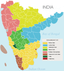
- 2008-01-07 02:35 AreJay 690×726×0 (615141 bytes) {{Information |Description= [[South India]]n states prior to the ''[[States Reorganisation Act]]'' (1956) |Source=self-made |Date= Jan 6, 2008 |Location= Atlanta, GA, USA |Author= [[User:AreJay|]] |Permission= GFDL, CC-Attrib |other_versions={{DerivativeVersions|South Indian territories 2009 de.svg}} }}
सञ्चिकायाः इतिहासः
सञ्चिका तत्समये कीदृशी आसीदिति द्रष्टुं दिनाङ्कः/समयः नुद्यताम् ।
| दिनाङ्कः/समयः | लघ्वाकृतिः | आयामाः | सदस्यः | टिप्पणी | |
|---|---|---|---|---|---|
| वर्तमानः | २३:३७, २३ नवेम्बर् २०१४ | | ६७२ × ७४६ (३०६ KB) | Ras67 | black frame and Illustrator data removed |
| ०१:३५, १३ जून् २००८ |  | ६९३ × ७४८ (७०८ KB) | File Upload Bot (Magnus Manske) | {{BotMoveToCommons|en.wikipedia}} {{Information |Description={{en|en:South Indian states prior to the ''en:States Reorganisation Act'' (1956)<br/> == Source data and maps == 1. Nizam's Territories: http://mahbubia.com/images/Map%20of%20Hyderab |
सञ्चिकायाः उपयोगः
अनया सञ्चिकया सह न किमपि पृष्ठं सल्लग्नम् अस्ति
वैश्विकसञ्चिकायाः उपयोगः
एतां सञ्चिकाम् अधोनिर्दिष्टाः वीक्यः उपयुञ्जते:
- ar.wikipedia.org इत्यस्मिन् उपयोगः
- bn.wikipedia.org इत्यस्मिन् उपयोगः
- ca.wikipedia.org इत्यस्मिन् उपयोगः
- en.wikipedia.org इत्यस्मिन् उपयोगः
- es.wikipedia.org इत्यस्मिन् उपयोगः
- eu.wikipedia.org इत्यस्मिन् उपयोगः
- fa.wikipedia.org इत्यस्मिन् उपयोगः
- fr.wikipedia.org इत्यस्मिन् उपयोगः
- he.wikipedia.org इत्यस्मिन् उपयोगः
- hi.wikipedia.org इत्यस्मिन् उपयोगः
- id.wikipedia.org इत्यस्मिन् उपयोगः
- kn.wikipedia.org इत्यस्मिन् उपयोगः
- ml.wikipedia.org इत्यस्मिन् उपयोगः
- mr.wikipedia.org इत्यस्मिन् उपयोगः
- ms.wikipedia.org इत्यस्मिन् उपयोगः
- ne.wikipedia.org इत्यस्मिन् उपयोगः
- ru.wikipedia.org इत्यस्मिन् उपयोगः
- ta.wikipedia.org इत्यस्मिन् उपयोगः
- te.wikipedia.org इत्यस्मिन् उपयोगः
अस्याः सञ्चिकायाः वैश्विकोपयोगस्य अधिकविवरणम् दृश्यताम् ।