मूलसञ्चिका(SVG सञ्चिका, साधारणं ७६८ × १,१५९ चित्राणवः (pixels), सञ्चिकायाः आकारः : ३११ KB)

Wikimedia Commons इत्यतः उद्धृता एषा सञ्चिका अन्येषु प्रकल्पेषु उपयोगार्हा । अस्याः सञ्चिकायाः सञ्चिकाविवरणपृष्ठम् इत्यत्र उपलभ्यमानं विवरणम् अधोलिखितं वर्तते ।

सारांशः

वर्णनम्
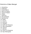
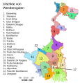
English: Original summary by creator of base svg file deeptrivia. Districts of West Bengal

Based on https://web.archive.org/web/20040606103522/www.censusindia.net/results/2001maps/wbengal01.html

Modifications by Mouryan:

  1. upladed translated version of File:WestBengalDistricts numbered de.svg.
  2. The districts of Dakshin 24 Parganas district and Uttar 24 Parganas were incorrectly numbered in the Map. The errors have been rectified.

Modifications by Furfur:

  1. The 4 (four) new districts of West Bengal namely Paschim Bardhaman district (bifurcated from Bardhaman district), Kalimpong district (bifurcated from Darjeeling district), Alipurduar district (bifurcated from Jalpaiguri district) and Jhargram district (bifurcated from Paschim Medinipur district) has been shown in this new Updated map.

Modifications by Antorjal:

  1. Midnapore District has been bifurcated to show both Paschim Medinipur and Purba Medinipur.
  2. Numbered and listed districts per comments at peer-review.
  3. Font size reduced for clarity, since the districts are now listed.
  4. Many of the spellings did not conform to linked articles in the text. All spellings now match the West Bengal article spellings.
दिनाङ्क ८ अक्टोबर् २००६ (original upload date)
स्रोतः Transferred from en.wikipedia to Commons by Padawane.
लेखकः इसका मूल अपलोड करने वाला आङ्ग्लभाषा विकिपीडिया पर Antorjal है।
अन्यानि संस्करणानि

[सम्पाद्यताम्]

SVG genesis
InfoField
 
The source code of this SVG is invalid due to an error.
 
इस W3Cअमान्य वेक्टर चित्र को Adobe Illustrator की मदद से बनाया गया था,
 
and with Inkscape.
 
 This map uses embedded text that can be easily translated using a text editor.

अनुमतिदानम्

w:hi:क्रिएटिव कॉमन्स
समारोपः (attribution) समानतया वितर्यताम्
इस फ़ाइल को क्रिएटिव कॉमन्स श्रेय-समानसांझा 2.5 साधारण, 2.0 साधारण और 1.0 साधारण लाइसेंस के अंतर्गत लाइसेंस किया गया है।
त्वं स्वतन्त्रः/स्वतन्त्रा :
  • वितरितकरणार्थम् – प्रतिलिपिकरणार्थं, वितरितकरणार्थं, सञ्चारितकरणार्थं च
  • सुशोभयितुम् (to remix) – कार्यम् अनुकूलं करणार्थम्
निम्नलिखितावस्थानाम् अन्तर्गततया :
  • समारोपः (attribution) – भवता/भवत्या रचनायाः श्रेयः उपयोगसंस्थितकत्रा अथवा लेखकेन दर्शितमाध्यमेन दातव्यः भविष्यति । (परन्तु सः भवते/भवत्यै अथवा भवता/भवत्या रचनायाः प्रयोगस्य समर्थनं करोति इति तस्य विचारः न भवेत्)।
  • समानतया वितर्यताम् – यदि भवान्/भवती एतस्मिन् कार्ये किमपि परिवर्तनं, अस्य आधारेण नवीनरचनां वा करोति, तर्हि नवरचितरचनायाः वितरणम् एतस्याः उत एतादृश्याः उपयोगसंस्थित्याः अन्तर्गततया कर्तुं शक्नोति ।
w:hi:क्रिएटिव कॉमन्स
समारोपः (attribution) समानतया वितर्यताम्
एषा सञ्चिका क्रिएटिव कॉमन्स-Attribution-Share Alike 3.0 Unported अनुमतिपत्रान्तर्गततया अस्ति । Subject to disclaimers.
त्वं स्वतन्त्रः/स्वतन्त्रा :
  • वितरितकरणार्थम् – प्रतिलिपिकरणार्थं, वितरितकरणार्थं, सञ्चारितकरणार्थं च
  • सुशोभयितुम् (to remix) – कार्यम् अनुकूलं करणार्थम्
निम्नलिखितावस्थानाम् अन्तर्गततया :
  • समारोपः (attribution) – भवता/भवत्या रचनायाः श्रेयः उपयोगसंस्थितकत्रा अथवा लेखकेन दर्शितमाध्यमेन दातव्यः भविष्यति । (परन्तु सः भवते/भवत्यै अथवा भवता/भवत्या रचनायाः प्रयोगस्य समर्थनं करोति इति तस्य विचारः न भवेत्)।
  • समानतया वितर्यताम् – यदि भवान्/भवती एतस्मिन् कार्ये किमपि परिवर्तनं, अस्य आधारेण नवीनरचनां वा करोति, तर्हि नवरचितरचनायाः वितरणम् एतस्याः उत एतादृश्याः उपयोगसंस्थित्याः अन्तर्गततया कर्तुं शक्नोति ।
इयम् अनुमतिशृङ्खला GFDL भागत्वेन अस्यां सञ्चिकायां योजितम् अनुमतेः अद्यतनीकरणम्
GNU head अस्य प्रलेखस्य प्रतिकृतीकरणं, पुनर्वितरणं, परिवर्तनं वा / च कर्तुम् अधोनिर्दिष्टनियमानुसारम् अनुमतिः दत्ता GNU Free Documentation License, Version 1.2 or any later version published by the Free Software Foundation; with no Invariant Sections, no Front-Cover Texts, and no Back-Cover Texts. A copy of the license is included in the section entitled GNU Free Documentation License Subject to disclaimers.

मूलनिवेशनप्रणाली

The original description page was here. All following user names refer to en.wikipedia.
  • 2006-12-25 04:28 Deeptrivia 450×500×0 (102714 bytes) Repair attempt
  • 2006-12-25 04:17 Deeptrivia 450×500×0 (101044 bytes) Repair attempt
  • 2006-10-08 14:21 Antorjal 450×500×0 (100501 bytes) Original summary by creator of base svg file [[User:deeptrivia|deeptrivia]]. Districts of West Bengal Based on http://web.archive.org/web/20040606103522/www.censusindia.net/results/2001maps/wbengal01.html Modifications by [[User:Antorjal|An
  • 2006-10-08 14:17 Antorjal 450×500×0 (100294 bytes) Original summary by creator of base svg file [[User:deeptrivia|deeptrivia]]. Districts of West Bengal Based on http://web.archive.org/web/20040606103522/www.censusindia.net/results/2001maps/wbengal01.html Modifications by [[User:Antorjal|An
  • 2006-10-08 14:15 Antorjal 450×500×0 (100501 bytes) Original summary by creator of base svg file [[User:deeptrivia|deeptrivia]]. Districts of West Bengal Based on http://web.archive.org/web/20040606103522/www.censusindia.net/results/2001maps/wbengal01.html Modifications by [[User:Antorjal|An
  • 2006-10-08 14:09 Antorjal 450×500×0 (100484 bytes) Original summary by creator of base svg file [[User:deeptrivia|deeptrivia]]. Districts of West Bengal Based on http://web.archive.org/web/20040606103522/www.censusindia.net/results/2001maps/wbengal01.html Modifications by [[User:Antorjal|An
  • 2006-10-08 14:05 Antorjal 450×500×0 (100501 bytes) Original summary by creator of base svg file [[User:deeptrivia|deeptrivia]]. Districts of West Bengal Based on http://web.archive.org/web/20040606103522/www.censusindia.net/results/2001maps/wbengal01.html Modifications by [[User:Antorjal|An

Captions

Add a one-line explanation of what this file represents
Map of West Bengal

८ अक्टोबर् 2006

media type आङ्ग्लभाषा

image/svg+xml

सञ्चिकायाः इतिहासः

सञ्चिका तत्समये कीदृशी आसीदिति द्रष्टुं दिनाङ्कः/समयः नुद्यताम् ।

दिनाङ्कः/समयःलघ्वाकृतिःआयामाःसदस्यःटिप्पणी
वर्तमानः२१:०४, २५ एप्रिल् २०२०२१:०४, २५ एप्रिल् २०२० समये विद्यमानायाः आवृत्तेः अंगुष्ठनखाकारः७६८ × १,१५९ (३११ KB)Debjitpaul10Updated text
२०:४५, २५ एप्रिल् २०२०२०:४५, २५ एप्रिल् २०२० समये विद्यमानायाः आवृत्तेः अंगुष्ठनखाकारः७६८ × १,१५९ (११३ KB)Debjitpaul10Uploaded a corrected and transparent version.
०६:१५, ५ नवेम्बर् २०१७०६:१५, ५ नवेम्बर् २०१७ समये विद्यमानायाः आवृत्तेः अंगुष्ठनखाकारः५७६ × ६०१ (१४४ KB)Mouryan{{Information |Description={{en|Original summary by creator of base svg file deeptrivia. Districts of West Bengal Based on http://web.archive.org/web/20040606103522/www.censusindia.net/results/2001maps/wbengal01.html Modificati...
०२:५१, ५ नवेम्बर् २०१७०२:५१, ५ नवेम्बर् २०१७ समये विद्यमानायाः आवृत्तेः अंगुष्ठनखाकारः५७६ × ६०१ (१४४ KB)Mouryan{{Information |Description={{en|Original summary by creator of base svg file deeptrivia. Districts of West Bengal Based on http://web.archive.org/web/20040606103522/www.censusindia.net/results/2001maps/wbengal01.html Modificati...
१३:५९, २५ नवेम्बर् २००८१३:५९, २५ नवेम्बर् २००८ समये विद्यमानायाः आवृत्तेः अंगुष्ठनखाकारः१,५९५ × २,२५६ (२१२ KB)GDibyendu{{Information |Description=fixed map (sunderbans), fixed district names |Source=based on locator map:West_Bengal_locator_map.svg |Date=2008-11-25 |Author=GDibyendu |Permission=All |other_versions= }}
२०:३०, २४ नवेम्बर् २००८२०:३०, २४ नवेम्बर् २००८ समये विद्यमानायाः आवृत्तेः अंगुष्ठनखाकारः४५० × ५०० (१०० KB)GDibyenduReverted to version as of 14:58, 17 January 2008 as some error crept in today's attempted upload
२०:१४, २४ नवेम्बर् २००८२०:१४, २४ नवेम्बर् २००८ समये विद्यमानायाः आवृत्तेः अंगुष्ठनखाकारः१,५९५ × २,२५६ (१९१ KB)GDibyendu{{Information |Description=Corrected the map (it was not showing sunderbans are properly) |Source=This map is based on locator map of West Bengal (West_Bengal_locator_map.svg) |Date=2008-11-24 |Author=GDibyendu |Permission=All |other_versions= }}
१७:४३, २२ नवेम्बर् २००८१७:४३, २२ नवेम्बर् २००८ समये विद्यमानायाः आवृत्तेः अंगुष्ठनखाकारः४५० × ५०० (१०० KB)GDibyenduReverted to version as of 14:58, 17 January 2008
१७:४१, २२ नवेम्बर् २००८१७:४१, २२ नवेम्बर् २००८ समये विद्यमानायाः आवृत्तेः अंगुष्ठनखाकारः४५० × ५०० (७ KB)GDibyendu{{Information |Description=Rewrote text in image to improve readability |Source=Based on last version |Date=2008-11-22 |Author=GDibyendu |Permission=All |other_versions= }}
१४:५८, १७ जनवरी २००८१४:५८, १७ जनवरी २००८ समये विद्यमानायाः आवृत्तेः अंगुष्ठनखाकारः४५० × ५०० (१०० KB)File Upload Bot (Magnus Manske) {{BotMoveToCommons|en.wikipedia}} {{Information |Description={{en|Original summary by creator of base svg file deeptrivia. Districts of West Bengal Based on http://web.archive.org/web/20040606103522/www.censusindia.net/results/200

अनया सञ्चिकया सह न किमपि पृष्ठं सल्लग्नम् अस्ति

वैश्विकसञ्चिकायाः उपयोगः

एतां सञ्चिकाम् अधोनिर्दिष्टाः वीक्यः उपयुञ्जते:

अस्याः सञ्चिकायाः वैश्विकोपयोगस्य अधिकविवरणम् दृश्यताम् ।

प्रदत्तांशः (दत्तांशविषयकदत्तांशः अयम्)

"https://sa.wikipedia.org/wiki/सञ्चिका:WestBengalDistricts_numbered.svg" इत्यस्माद् प्रतिप्राप्तम्