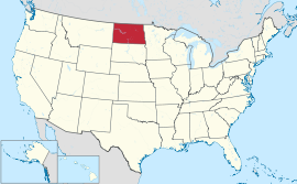
नार्थ डेकोटा
नार्थ डेकोटा संयुक्त राज्य अमेरिका देशस्य प्रदेश: अस्ति. राजधानी - फार्गो
| State of North Dakota | |||||
| |||||
| Nickname(s): Peace Garden State, Roughrider State, Flickertail State | |||||
| Motto(s): Liberty and Union, Now and Forever, One and Inseparable | |||||
 | |||||
| Official language(s) | English[१] | ||||
| Demonym | North Dakotan | ||||
| Capital | Bismarck | ||||
| Largest city | Fargo | ||||
| Largest metro area | Fargo metropolitan area | ||||
| Area | Ranked 19th in the U.S. | ||||
| - Total | 70,700 sq mi (183,272 km2) | ||||
| - Width | 211[उद्धरणं वाञ्छितम्] miles (340 km) | ||||
| - Length | 340 miles (545 km) | ||||
| - % water | 2.4 | ||||
| - Latitude | 45° 56′ N to 49° 00′ N | ||||
| - Longitude | 96° 33′ W to 104° 03′ W | ||||
| Population | Ranked 48th in the U.S. | ||||
| - Total | 723,393 (2013 est) | ||||
| - Density | 11.70/sq mi (3.83/km2) Ranked 47th in the U.S. | ||||
| Elevation | |||||
| - Highest point | White Butte[२][३] 3,508 ft (1069 m) | ||||
| - Mean | 1,900 ft (580 m) | ||||
| - Lowest point | Red River of the North at Manitoba border[२][३] 751 ft (229 m) | ||||
| Admission to Union | November 2, 1889[a] (39th) | ||||
| Governor | Jack Dalrymple (R) | ||||
| Lieutenant Governor | Drew Wrigley (R) | ||||
| Legislature | Legislative Assembly | ||||
| - Upper house | Senate | ||||
| - Lower house | House of Representatives | ||||
| U.S. Senators | John Hoeven (R) Heidi Heitkamp (D) | ||||
| U.S. House delegation | Kevin Cramer (R) (list) | ||||
| Time zones | |||||
| - most of state | Central: UTC -6/-5 | ||||
| - southwest | Mountain: UTC -7/-6 | ||||
| Abbreviations | ND US-ND | ||||
| Website | www.nd.gov | ||||
सम्बद्ध विषया:
सम्पादयतुटिप्पणी
सम्पादयतु- ↑ "North Dakota Century Code, CHAPTER 54-02-13" (PDF). आह्रियत September 13, 2013.
- ↑ २.० २.१ "Elevations and Distances in the United States". United States Geological Survey. 2001. Archived from the original on November 9, 2013. आह्रियत October 24, 2011.
- ↑ ३.० ३.१ Elevation adjusted to North American Vertical Datum of 1988.
बाह्यसम्पर्कतन्तुः
सम्पादयतु- State of North Dakota official website
- North Dakota tourism website
- Energy Profile for North Dakota
- USGS real-time, geographic, and other scientific resources of North Dakota
- U.S. Census Bureau facts of North Dakota Archived २००६-०६-१५ at the Wayback Machine
- North Dakota State Facts – USDA
- Pictures of the Dakotas: Badlands and Theodore Roosevelt National Parks
- GhostsOfNorthDakota.com – a pictorial documentary of North Dakota "ghost towns"
- नार्थ डेकोटा}
अमेरिकासंयुक्तराज्यम् राज्या व राजधानी
